| Online Version - Abmelden / Unsubscribe |
 |
16.03.2015
The current Smallworld GIS version 4.3 includes numerous improvements and new features for both users and system administrators. Smallworld GIS 4.3 provides support for up-to-date operating systems and a secure integration of other products such as the GeoNAM asset management suite or trascue.PIMS integrity management. Updating your Smallworld version brings easier maintenance and better performance.
Here are some of the most important changes:
|
|
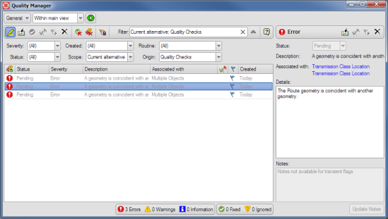
Integrity Checker is replaced by the new Quality Manager. The users can start quality routines configured by a system administrator. Quality routines can check data for errors or incompleteness. The data checking process can be limited spatially using the trail or current map view, or it can scan the entire database.
|
|
Conflict resolution on the attribute level
Starting with version 4.3, conflicts can be edited and resolved on the level of individual data attributes. For simple, pre-defined cases, alternative management can even provide automated solutions.
|
|
Backup Manager comes with an improved user interface, guiding system administrators through their work processes systematically. Several scripts have been made available, which helps save programming time.
|
|
A new user interface makes the data model tool much easier to handle, especially for new users. The tool provides a “History View” that shows at a glance which modules are installed and which updates are available or required. The tool also supports system migration, e.g., from 4.1x to 4.3 or to future versions.
|
|
SWIFT (SmallWorld user InterFace Toolkit) is a new layer completely developed in Magik. It is platform independent, which means that there are no restrictions regarding operating system APIs, interfaces are more flexible, and Release Updates can be distributed via TSBs. The new SWIFT functionality provides developers of user interfaces with much more flexibility for their designs. The end users profit from a clearer interface that can guide them in completing their work processes.
|
|
Version 4.3 supports the ANT tool for automatically compiling source code into executable programs. ANT is used for automatically generating Magik images and gis_alias files, controlled by XML build files.
|
|
For users:
- Map component with Google-like look and feel
- Easier selection of text and point geometries
- Additional functions such as tooltips for greyed-out buttons or triple-click for text selection
- Improved user interface for cluster and neighborhood analyses
- Improved reference point dimensioning with up to 100 target points
For system administrators:
- Stable base for up-to-date operating systems
- Comparison and management functions for complex data model changes
- More flexible interface design
- Object properties have been detached from the ACE with a new UI
For developers:
- Corrections of spatial predicates
|
|
|
|
GEOMAGIC GmbH
Friedrich-Ebert-Straße 33
04109 Leipzig, Germany
Fon: +49 (0)341 7111700
E-Mail: marketing@geomagic.de
www.geomagic.de/en |
|
|